 @toxi@mastodon.thi.ng
2025-06-05 08:48:40
"Eventually, I stopped responding to my body. I was responding instead to a dashboard." — @…
This is a great point and very much translates to so many other parts of life/work where people stop listening to their "body" (or to their org/product/offering), outsourcing/numbing/dumbing down their decision making based on dashboards of col…

 @tiotasram@kolektiva.social
2025-07-04 20:14:31
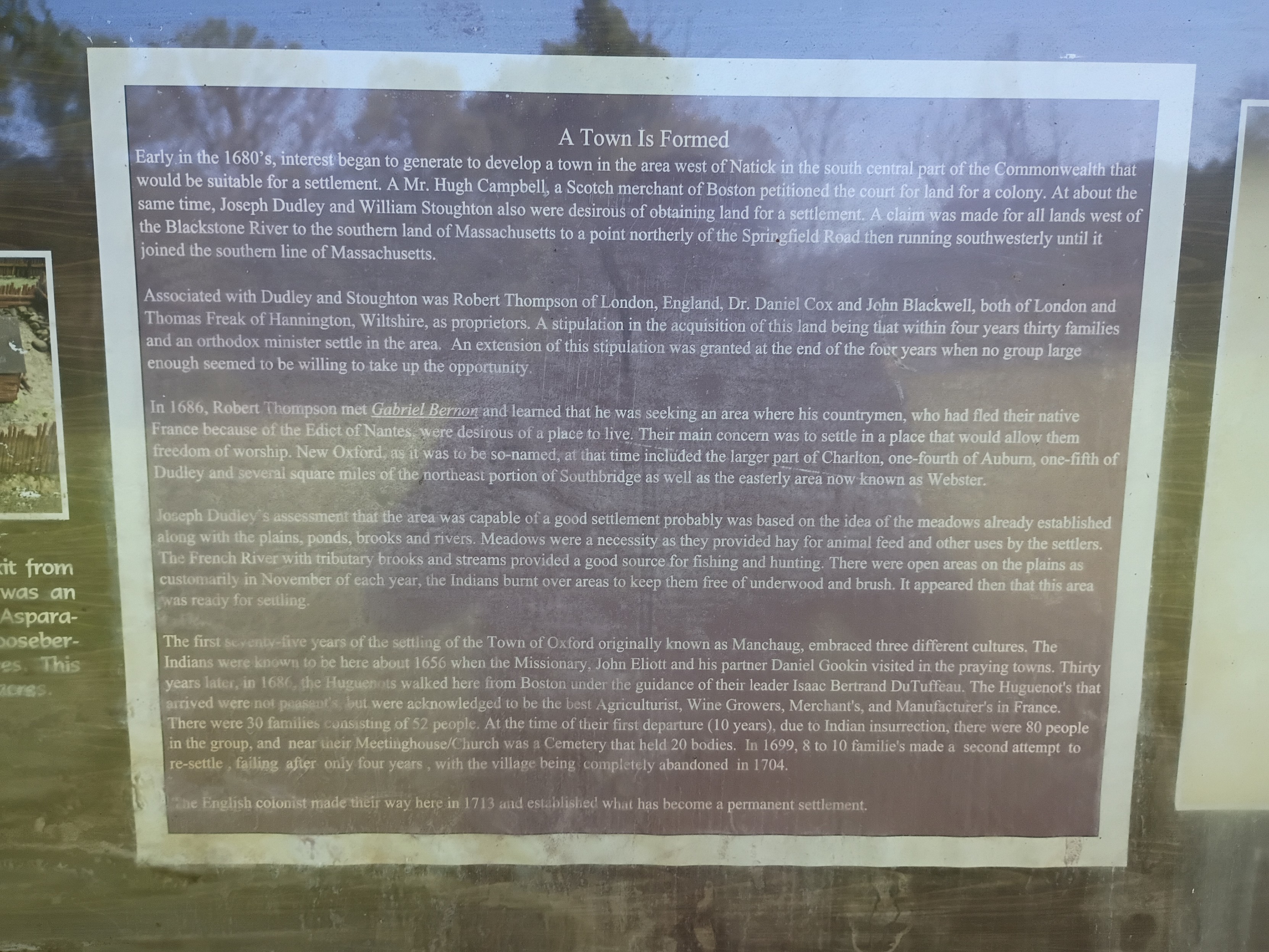
Long; central Massachusetts colonial history
Today on a whim I visited a site in Massachusetts marked as "Huguenot Fort Ruins" on OpenStreetMaps. I drove out with my 4-year-old through increasingly rural central Massachusetts forests & fields to end up on a narrow street near the top of a hill beside a small field. The neighboring houses had huge lawns, some with tractors.
Appropriately for this day and this moment in history, the history of the site turns out to be a microcosm of America. Across the field beyond a cross-shaped stone memorial stood an info board with a few diagrams and some text. The text of the main sign (including typos/misspellings) read:
"""
Town Is Formed
Early in the 1680's, interest began to generate to develop a town in the area west of Natick in the south central part of the Commonwealth that would be suitable for a settlement. A Mr. Hugh Campbell, a Scotch merchant of Boston petitioned the court for land for a colony. At about the same time, Joseph Dudley and William Stoughton also were desirous of obtaining land for a settlement. A claim was made for all lands west of the Blackstone River to the southern land of Massachusetts to a point northerly of the Springfield Road then running southwesterly until it joined the southern line of Massachusetts.
Associated with Dudley and Stoughton was Robert Thompson of London, England, Dr. Daniel Cox and John Blackwell, both of London and Thomas Freak of Hannington, Wiltshire, as proprietors. A stipulation in the acquisition of this land being that within four years thirty families and an orthodox minister settle in the area. An extension of this stipulation was granted at the end of the four years when no group large enough seemed to be willing to take up the opportunity.
In 1686, Robert Thompson met Gabriel Bernor and learned that he was seeking an area where his countrymen, who had fled their native France because of the Edict of Nantes, were desirous of a place to live. Their main concern was to settle in a place that would allow them freedom of worship. New Oxford, as it was the so-named, at that time included the larger part of Charlton, one-fourth of Auburn, one-fifth of Dudley and several square miles of the northeast portion of Southbridge as well as the easterly ares now known as Webster.
Joseph Dudley's assessment that the area was capable of a good settlement probably was based on the idea of the meadows already established along with the plains, ponds, brooks and rivers. Meadows were a necessity as they provided hay for animal feed and other uses by the settlers. The French River tributary books and streams provided a good source for fishing and hunting. There were open areas on the plains as customarily in November of each year, the Indians burnt over areas to keep them free of underwood and brush. It appeared then that this area was ready for settling.
The first seventy-five years of the settling of the Town of Oxford originally known as Manchaug, embraced three different cultures. The Indians were known to be here about 1656 when the Missionary, John Eliott and his partner Daniel Gookin visited in the praying towns. Thirty years later, in 1686, the Huguenots walked here from Boston under the guidance of their leader Isaac Bertrand DuTuffeau. The Huguenot's that arrived were not peasants, but were acknowledged to be the best Agriculturist, Wine Growers, Merchant's, and Manufacter's in France. There were 30 families consisting of 52 people. At the time of their first departure (10 years), due to Indian insurrection, there were 80 people in the group, and near their Meetinghouse/Church was a Cemetery that held 20 bodies. In 1699, 8 to 10 familie's made a second attempt to re-settle, failing after only four years, with the village being completely abandoned in 1704.
The English colonist made their way here in 1713 and established what has become a permanent settlement.
"""
All that was left of the fort was a crumbling stone wall that would have been the base of a higher wooden wall according to a picture of a model (I didn't think to get a shot of that myself). Only trees and brush remain where the multi-story main wooden building was.
This story has so many echoes in the present:
- The rich colonialists from Boston & London agree to settle the land, buying/taking land "rights" from the colonial British court that claimed jurisdiction without actually having control of the land. Whether the sponsors ever actually visited the land themselves I don't know. They surely profited somehow, whether from selling on the land rights later or collecting taxes/rent or whatever, by they needed poor laborers to actually do the work of developing the land (& driving out the original inhabitants, who had no say in the machinations of the Boston court).
- The land deal was on condition that there capital-holders who stood to profit would find settlers to actually do the work of colonizing. The British crown wanted more territory to be controlled in practice not just in theory, but they weren't going to be the ones to do the hard work.
- The capital-holders actually failed to find enough poor suckers to do their dirty work for 4 years, until the Huguenots, fleeing religious persecution in France, were desperate enough to accept their terms.
- Of course, the land was only so ripe for settlement because of careful tending over centuries by the natives who were eventually driven off, and whose land management practices are abandoned today. Given the mention of praying towns (& dates), this was after King Phillip's war, which resulted in at least some forced resettlement of native tribes around the area, but the descendants of those "Indians" mentioned in this sign are still around. For example, this is the site of one local band of Nipmuck, whose namesake lake is about 5 miles south of the fort site: #LandBack.
 @davidaugust@mastodon.online
2025-06-06 01:26:17
Having nothing to do with current events, might I suggest reading my “children’s story” Winnie the Coup and Elongated Muskrat Bulldoze the Gubment tonight before bed?
https://medium.com/the-haven/winnie-the-coup-and-the-elongated-musk…

 @tezoatlipoca@mas.to
2025-08-03 15:06:08
As much as this scratches the cool itch (and I wish I had a laptop that had a usb-c power-in connection), I can't keep from thinking we're all eventually going to be like Tony Stark in that cave (pre-mark1 suit) lugging that car battery around.
https://fed.brid.g…

 @aral@mastodon.ar.al
2025-07-01 06:59:46
Had my talk on Small Web accepted at #why2025 but I hadn’t realised (my bad) that not only do you have to cover your own travel and accommodation but you also have to buy a ticket to speak. I’m sorry, as part of a tiny two-person not-for-profit working for the common good, I can’t afford to pay to speak at events. I’m not Deloitte. So I sadly had to withdraw my talk.
If any conferences do w…
 @tml@urbanists.social
2025-06-02 21:42:40
 @w6kme@mastodon.radio
2025-06-30 01:43:19
Pics and reports on @ARRLFieldDay to follow once I've had a day to recover a bit. The club (CVARC) where I am the Field Day coordinator operated a 23A setup in challenging band conditions and I'm just amazed at how well everyone pulled together to do it. Not confirmed yet, but it's expected to be the largest such operation in the country again.
Between setup, the 24 hour event and breakdown, I walked nearly 40 miles. 🥾 A real long covid victory, that.
 @jacobgudiol@mastodonsweden.se
2025-05-26 19:47:20

 @ruth_mottram@fediscience.org
2025-06-25 14:12:53
Man i wish I were around on the 16th July in Copenhagen - this #SlowTech event sounds too cool for words!
HT @… ...
https://dukop.dk/en/event/8095/
 @Cognessence@social.linux.pizza
2025-08-03 01:47:57
Often we will say something like, "how do I put this?" - but what is the 'this' that you're trying to 'put'? In a split second (or thereabouts) we do put it in language, but whatever that idea, inspiration or unconscious thought-thing *is* that we then formulate/communicate is endlessly fun to...think...about. :D
Has anyone here had experiences like August Kekulé, where non-lingual (usually pictorial) mental event solved a serious logical problem?