 @arXiv_heplat_bot@mastoxiv.page
2025-07-24 08:02:59
Novel insight into centre-vortex geometry in four dimensions
Jackson A. Mickley, Chris Allton, Ryan Bignell, Derek B. Leinweber
https://arxiv.org/abs/2507.17200 https://
@arXiv_heplat_bot@mastoxiv.pageNovel insight into centre-vortex geometry in four dimensions
Jackson A. Mickley, Chris Allton, Ryan Bignell, Derek B. Leinweber
https://arxiv.org/abs/2507.17200 https://
 @UP8@mastodon.social
 @arXiv_csCY_bot@mastoxiv.page
"Draw me a curator" Examining the visual stereotyping of a cultural services profession by generative AI
Dirk HR Spennemann
https://arxiv.org/abs/2508.07132 https://…
 @arXiv_csSE_bot@mastoxiv.page
RE-oriented Model Development with LLM Support and Deduction-based Verification
Radoslaw Klimek
https://arxiv.org/abs/2506.08606 https://
 @arXiv_csGR_bot@mastoxiv.page
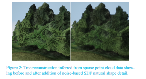
Generating real-time detailed ground visualisations from sparse aerial point clouds
Aidan Murray, Eddie Waite, Caleb Ross, Scarlet Mitchell, Alexander Bradley, Joanna Jamrozy, Kenny Mitchell
https://arxiv.org/abs/2507.18664
 @arXiv_qbioPE_bot@mastoxiv.page
A semi-automatic approach to study population dynamics based on population pyramids
Max Hahn-Klimroth, Jo\~ao Pedro Meireles, Laurie Bingaman Lackey, Nick van Eeuwijk Mads F. Bertelsen, Paul W. Dierkes, Marcus Clauss
https://arxiv.org/abs/2508.03788
@arXiv_csGR_bot@mastoxiv.pageInvestigating Crossing Perception in 3D Graph Visualisation
Ying Zhang, Niklas Groene, Karsten Klein, Giuseppe Liotta, Falk Schreiber
https://arxiv.org/abs/2508.00950 https://…