Tootfinder

Opt-in global Mastodon full text search. Join the index!

@hikingdude@mastodon.social
2026-06-27 09:25:15

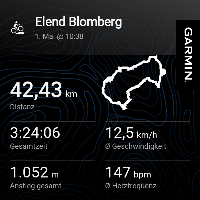
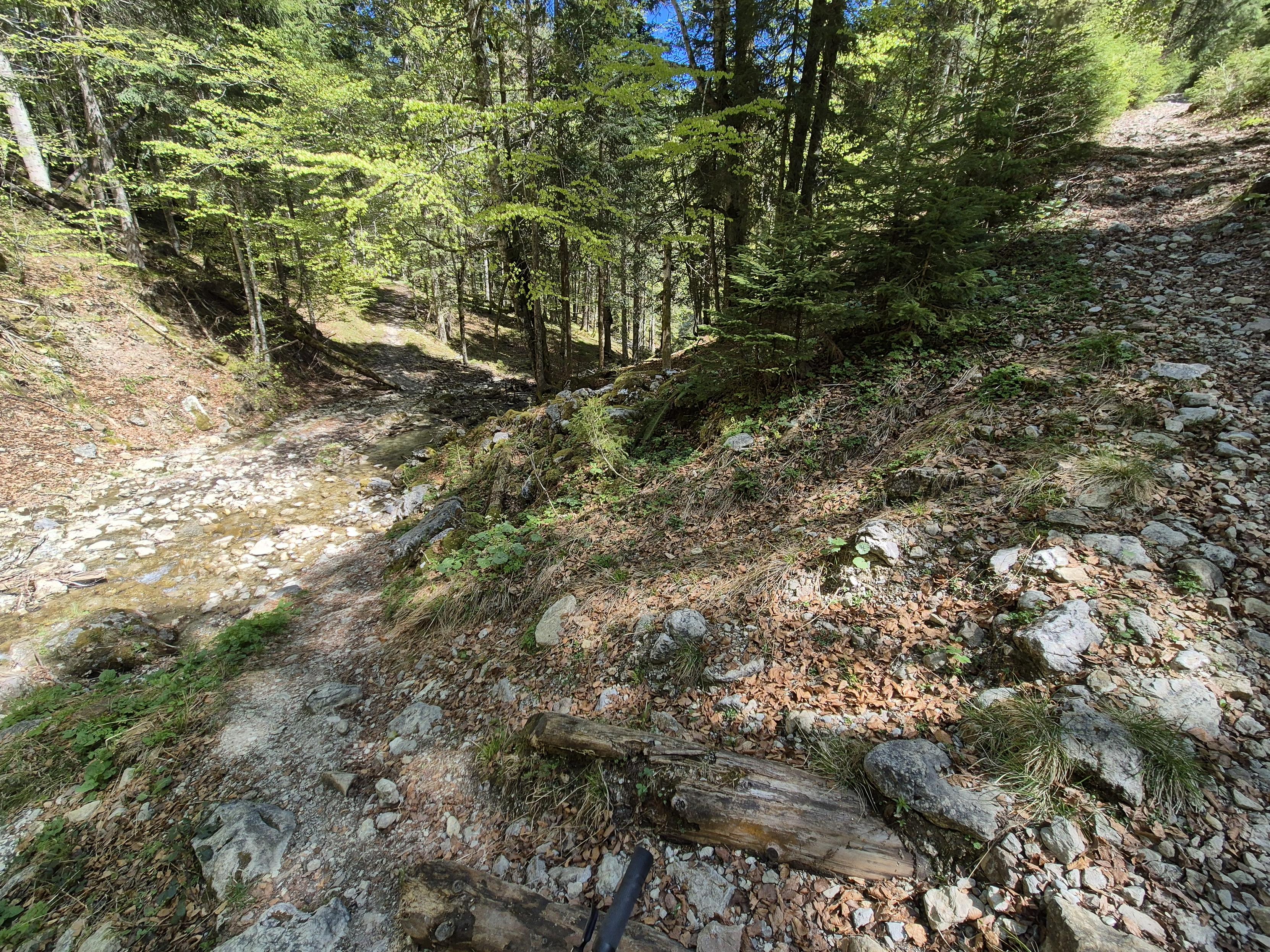
I set the alarm to 6am and we started at 7am. My wife cycled a small morning loop (like 45min) and I did a bit larger loop to test the 30 tooth Sprocket on longer climbs.
*Learnings today:*
- mosquitos can be a real motivator to push harder
- the sprocket feels good
- the #garmin incident detection works
- 1st aid kit is a good investment
- good medical coverage in …

This image captures a joyful and scenic moment during a cycling or mountain biking adventure. In the foreground, a person is taking a selfie, wearing a black helmet, glasses, and a bright yellow and gray cycling jersey. The individual is smiling, reflecting the enjoyment and excitement of the ride.
The background reveals a stunning mountainous landscape with rolling green hills dotted with evergreen trees. A winding dirt trail cuts through the meadow, leading the eye deeper into the scene. The …
This image is a Garmin Connect summary of a cycling activity titled "Wiesseer Höhenstraße", completed on June 27, 2026, at 06:57 in Gaißach. Here are the key details of the ride:
- Distance: 41.03 kilometers
- Total Time: 2 hours, 49 minutes, and 44 seconds
- Average Speed: 14.5 km/h
The image features a scenic background of a lush, green mountainous landscape with dense forests and a winding trail. The route trace is overlaid on the image, showing the path taken during the ride. The Garmin log…
@xtaran@chaos.social
2026-04-15 01:20:29

Weil mich die am alten #Brompton P-Lenker von Mr. #Winterbrompton immer schrãg sitzende Gummiband-Halterung fürs #Garmin genervt hat und ich die schon vor 'ner Weile bestellte GoPro/Garmin-Halterung v…

Ein 16" Brompton mit altem P-Lenker von vorne gesehen. Der P-Lenker erinnert von der schmetterlingsförmigen Form her an dieLenker von Heimtrainern. In der Mitte auf dem Lenkkopf sitzen drei angeschaltete Frontleuchten (von unten nach oben: MagicShine Hori 1300, MagicShine Hori 900, Ravemen FR300) und ein Garmin GPS-Navi. Letzteres sitzt durch die Leuchten darunter auf einer Ebene mit den oberen Lenkergriffen. Man sieht auch noch die mit O-Ringen an einem schräg verlaufenden Lenkerteil der unter…
Der anz leicht nach hinten gekippte Stack aus drei Frontleuchten und Garmin am zusammengefalteten Brompton. Das Garmin sitzt bereits unterhalb der Vorderradachse und hat damit keine Platzprobleme.
Garmin-Sharepic basierend auf einem Selfie mit Brompton in einer Glastüre. Oben am Brompton-P-Lenker leuchtet hell etwas nahezu quadratisches. Ich habr eine gelbe Regenjacke, einen dunklen Schlauchschal und einen Velohelm an.

Unten stehen noch ein paar Eckdaten:

4.69km Distanz, 22min 45sec Gesamtfahrtzeit, 12.4km/h Durchschnittsgeschwindigkeit.
@luana@wetdry.world
2026-04-26 14:08:50

Hmmm the Garmins look interesting!
The Venu 4 (and Forerunner 970, tho that’s way too big for my wrist and more expensive) have most of what I want, and their phone app is optional!!
Not sure exactly what features I’d be missing with no phone connection (specially considering that it has no lte/mobile data), tho the phone app supports both iOS and Android so maybe once Bluetooth on Waydroid is a thing I could get that to work too!
I don’t think I’d be missing anything from my current Apple Watch (s5) or even from newer AWes other than the Ultras (which are also too big for my wrist, and too expensive). The Ultras have a depth sensor for diving which is really really cool, while the FR and Venu aren’t water resistant enough for that (Garmin has a way more specialised smartwatch for that, with a mostly non-overlapping featureset).
Both the FR and the Venu are rated for swimming, which is cool, but neither of those are proper for diving (I don’t really dive, tho that’s something I’m interested in trying out in the future). I think it should be safe enough for when I go around swimming in the pool or beach tho? Well, I don’t usually keep my Apple Watch on when swimming anyway. It’s just nice to know that if I were to get more sportive about that it’d be a possibility.
I think the only disadvantage of the Venu compared to the FR is the lack of a Maps app, tho that’s totally fine ig. Also no HR while swimming and less storage. The FR is 2mm bigger than my current 45mm s5 apple watch, and I already find this too big. The Venu has a 41mm option which is what I’d get if I decided to go for it.
OH AND THEY BOTH HAVE SUPER PRETTY COLOR OPTIONS, INCLUDING A LAVANDER ONE FOR THE VENU!! :blobcataww:
(the FR has lots of very pretty options too!!)
This is mostly just brainstorming rn, but does anyone around here have any experience with the Garmin smartwatches? It’d be nice to see opinions from someone who owns one of them :3
#Garmin #SmartWatch #Fitness

@hikingdude@mastodon.social
2026-05-08 20:43:08

The journey with my (likely) broken #Garmin Cycle computer continues:
I had some exchange with the Garmin support. They now open a ticket at the US-support ...
Meanwhile I saw a good offer for the successor model - and bought it. I don't believe mine will make it again. I guess I'll sell it - likely as defect (if it can't be fixed).
If garmin can get it back to live …

@phpmacher@sueden.social
2026-06-07 15:45:23

Ich habe ein #Garmin #Edge 520 und überlege, #OSM Karten zu nutzen
Wer hat Erfahrung damit?
Und welche sind zu empfehlen?
Velomap? Freizeitmap?

@hikingdude@mastodon.social
2026-05-01 18:28:45

This was a nice ride. Some sections involved pushing the bike. And some steep parts came a bit surprising. But overall it was nice with some quite challenging sections. It was a loop that I wanted to try since quite a while.
And it's a new elevation record since I own the Garmin 🎉
Just my #garmin now suddenly refuses to connect to my phone. 😵‍💫 Factory reset, all suggestions fro…

Here are the key details of the ride:

- **Distance:** 42.43 kilometers
- **Total Time:** 3 hours, 24 minutes, and 6 seconds
- **Average Speed:** 12.5 km/h
- **Total Ascent:** 1,052 meters
- **Average Heart Rate:** 147 beats per minute

The map trace shows the path taken, highlighting the shape and layout of the route. This appears to be a challenging ride with significant elevation gain. If you have any questions or need further analysis, feel free to ask!
A serene and rugged forest scene unfolds in this image, capturing the raw beauty of a mountainous trail. The foreground features a rocky, uneven path that winds its way through a dense woodland. The path is strewn with rocks, fallen leaves, and patches of moss, adding texture and a sense of natural wildness to the scene.

The trail is flanked by tall trees, their lush green foliage creating a natural canopy overhead. The trees add depth and a sense of peaceful solitude, their branches casting d…
@hikingdude@mastodon.social
2026-05-04 18:03:55

buhhhh - and my #Garmin disconnected again today after half an hour on the bike.
*sigh