@einzigartiger@chaos.social
2026-05-27 13:13:40
Erinnerung:
Nächste Woche (4.6. ab 19 Uhr) ist wieder #OpenStreetMap-Stammtisch in #Dresden
https://
@einzigartiger@chaos.socialErinnerung:
Nächste Woche (4.6. ab 19 Uhr) ist wieder #OpenStreetMap-Stammtisch in #Dresden
https://
 @seav@en.osm.town
This #Veritasium video is a damned good intro on routing algorithms starting with Dijkstra’s seminal shortest path algorithm. The visuals are impressive and they make extensive use of #OpenStreetMap data.
 @bogo@hapyyr.com
In the next 2 weeks we will be ready with our anti surveillance campaign that will educate people that they are cameras everywhere and we need to notice them, map them or do something even more creative with them.
We will use some #openstreetMap resources for that and work with a few artists to create a vision for "something is looking at me, and I had not noticed".
We ne…
 @stargazer@woof.tech
 @awinkler@openbiblio.social
Oh, da gibt es noch was zu tun. Über 8000 Objekte der Berliner Denkmalliste stehen auf Wikidata, haben aber noch keine Verlinkung zu #OpenStreetMap ( #OSM ): https://
@einzigartiger@chaos.socialMorgen (7.5.) ist wieder #OpenStreetMap-Stammtisch in Dresden. Kommt gerne vorbei und bringt Euer Fragen und Antworten rund um #OSM mit. Auch neue Mapper*innen sind willkommen.
Beginn 19 Uhr im Bottoms Up auf der Martin-Luther-Str.
 @hikingdude@mastodon.social
🤔 518 #Openstreetmap contributions using #Streetcomplete in the last 7 days. 💪
Improving #osm wherever we are.
 @mnalis@mastodon.online
Finally got to documenting my experiences and instructions for installing your own #Panoramax instance of #streetlevelimagery to help with #OpenStreetMap mapping - hopefully it might …
 @guerda@ruhr.social
Dear #OpenStreetMap community
Is there a QA tool for Simple 3D mapping checks?
I often struggle to configure building:min_level, building:levels, building:part correctly and I would like to get a quick check for those attributes.
#Osmose doesn't check to much for buildings, it does…
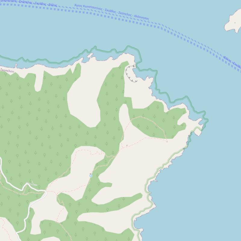
@seav@en.osm.townWhenever I see these obvious offsets in #OpenStreetMap, I have this itch to move them so they align with each other. But since I am not a local, I won’t do so and will leave it to Greek OpenStreetMappers to reconcile. But yeah, the 100-meter offset looks bad.
Island of Skopelos, #Greece 🇬🇷:
 @stsquad@mastodon.org.uk
#TIL about #osm-mode, allowing you to browse #openstreetmap from #emacs.
 @seav@en.osm.town
Welp, I guess I won’t be editing #OpenStreetMap for a bit. 🤷♂️
(Note: this appears to be an intermittent error.)
#HTTP503

 @vosje62@mastodon.nl