 @burger_jaap@mastodon.social
2026-06-01 14:31:50
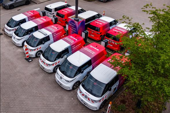
What does a fleet of Buzzies get up to when they’re not out and about on the job? They charge and discharge their batteries and trade kWh on the energy exchange.
I bet they're feeling really bullish on renewable energy!
https://www.
 @hex@kolektiva.social
2026-06-27 04:05:41
Now, I don't especially like the term "church" so I may use something else... like "coven." You can do what you want. But I happen to have already mapped out an example. (It is exactly that, just an example, so take if it's useful, change if you need, and don't stick to anything too closely.) Oh, this mapping also means that you would, for religious reasons, only be allowed to work under capitalism 4 days a week instead of 5.
Given the increases in productivity over the last 100 years, a 4 day work week is a completely reasonable expectation. If we have to annex Monday for the weekend by force of religion, so be it. It is rightfully ours anyway. If enough people try it, this will probably work. If it doesn't work, it just needs more people.
The Practice of Worship:
It is recommended to break down worship in to three sections: the functional, the communal, and the spiritual. It is also recommended to break these across multiple days. A common structure for some Christian churches is to take 10-15 minutes for announcements (Functional), an hour or two for services (Spiritual), followed by (Communal) coffee, tea, and cookies for an unspecified time up to two hours after. When starting or working with limited time a single compressed model like this may work, but it's not optimal.
- The Functional
The purpose of this section is to address the functional needs of the coven. Block out time (less than 90 minute blocks is recommended) to go through reports and updates from those involved in the Dispensary, Library, Works Committee (infrastructure), and Services Committee (providing services internally and, potentially, externally). Talk through any additional announcements, including those from other covens you may be federated with.
It is helpful to include unstructured communal time, such as shared meals, during or after functional meetings. As the federation grows, more time will be needed. It is recommended to break functional meetings, work parties, and such across multiple days. When a federation becomes sufficiently large, it is recommended to take every Monday, on top of Saturday and Sunday, as a third day of community and worship.
The scope of the functional spans 3 realms (which may be more-or-less fluid): the personal or family, the coven and federation, and humanity itself. It is up to each coven and individual to negotiate how to allocate the three days of the weekend once we have liberated Monday from the work week, but it is important to reserve it for one of these three. However, some people must work on weekends. Medical personnel, for example, cannot conform to a standard work week. While the work week should be universally restricted, which specific days are used will be up to the specific coven and their members.
A functional meeting can start with an agenda like the following:
Functional Invocation
Announcements
Report Backs
Dispensary
Inventory Check
What is low
What is empty
What is expiring
What is needed
Funds status
Library
Inventory Check and Items needing return
Library acquisition requests
Funds status and budget check
Works Committee
Upcoming projects
Subcommittee updates (Following the Works Committee agenda)
New committee formations
Funds status
Services Committee
New capabilities announcements
New needs requests
Subcommittee updates (Following the Works Committee agenda)
New committee formations
Funds status
Task Check
Breaking the Circle
This agenda is a suggestion for those who don't know where to start. It can be adapted or ignored as appropriate.
- The Spiritual
Spirituality is necessarily an undefined space. It is deeply personal. Each individual taking time to share their own personal spiritual experiences can help each connect with each other. This experience of connection can itself be a spiritual experience. It may also be useful to read esoteric, mystical, or philosophical texts together as type of "book club" and share thoughts. Others may draw from their own knowledge or traditions. This is something that must be defined together within a group.
- The Communal
The communal aspect of the practice of worship bind the coven and federation together. Within the community we find joy and release, connection and comfort. The coven is where we turn in times of need, and where we share our hopes and dreams.
 @cdarwin@c.im
2026-05-31 02:58:56
Artificial intelligence has triggered fierce competition for top talent and is also fueling tens of thousands of layoffs this year.
The class divide is widening in Silicon Valley as a tiny group of employees is landing unprecedented packages for AI skills,
while many others struggle to find work
The have-nots are doing everything that used to guarantee great jobs
— refreshing resumes, optimizing LinkedIn profiles and doing interviews
— but companies are much mo…
 @netzschleuder@social.skewed.de
2026-07-31 23:00:05
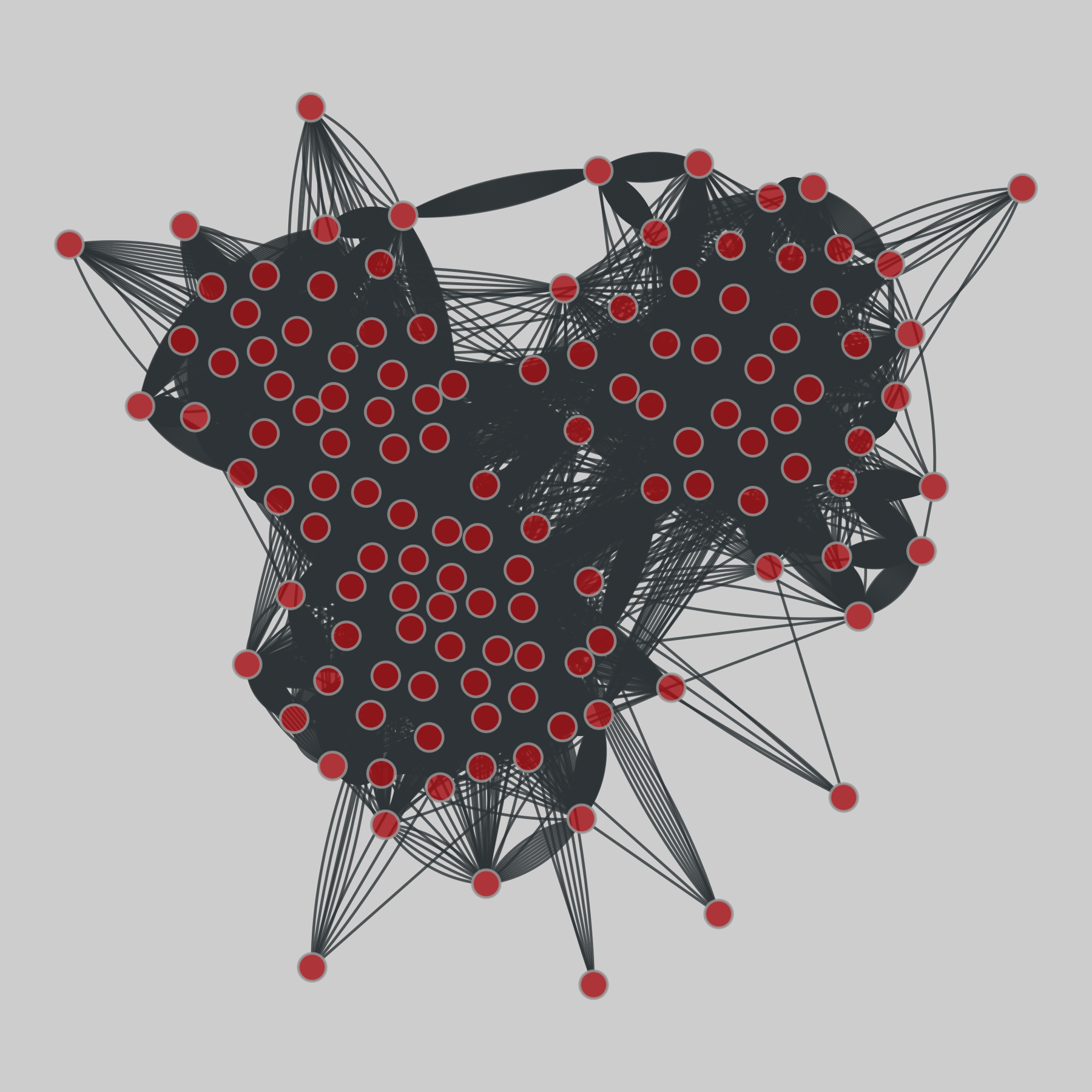
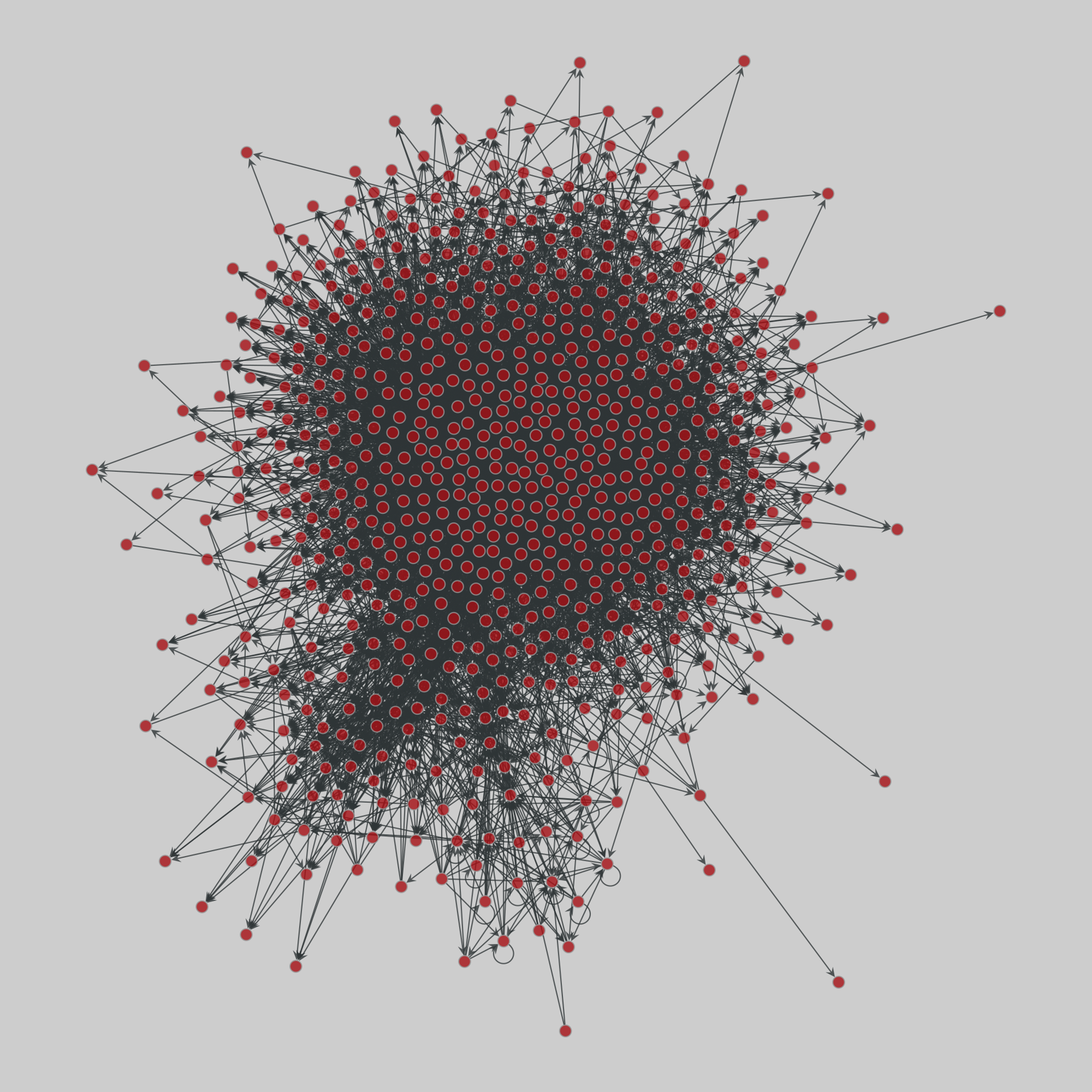
messal_shale: Messel Shale food web (2014)
A network of feeling links among taxa based on the 48 million years old uppermost early Eocene Messel Shale. Edge property 'certainty' denotes the certainty of the edge. Metadata include evidence, habitat, and trophic roles. The edge direction goes from consumer to resource.
This network has 700 nodes and 6444 edges.
Tags: Biological, Food Web, Uncertain, Weighted, Metadata
 @cdarwin@c.im
2026-06-29 06:12:54
NASA is racing to save an aging telescope from falling back to Earth with a daring rescue mission.
The $30 million salvage operation gets underway as soon as this week with the planned launch of a robotic lifesaver.
NASA hired startup
Katalyst Space Technologies
to boost the Swift Observatory to a higher orbit
where it can continue hunting for some of the universe’s biggest explosions.
A three-armed spacecraft built by Katalyst will chase after Swift once …
 @netzschleuder@social.skewed.de
2026-06-01 04:00:05
messal_shale: Messel Shale food web (2014)
A network of feeling links among taxa based on the 48 million years old uppermost early Eocene Messel Shale. Edge property 'certainty' denotes the certainty of the edge. Metadata include evidence, habitat, and trophic roles. The edge direction goes from consumer to resource.
This network has 700 nodes and 6444 edges.
Tags: Biological, Food Web, Uncertain, Weighted, Metadata
 @hex@kolektiva.social
2026-05-19 07:09:57
Logistics in the technical sense (part of supply chain management) is a subset of logistics in the vernacular sense ("the handling of the details of an operation"). You can explore this second and more general sense, and thereby build an understanding of the first and more technical sense, by iteratively asking the question, "how does one make that happen" and follow questions from there.
A big part of organizing is figuring out the (vernacular) logistics (and helping others figure it out). You want to organize a seed swap? Ok. How does one make that happen? Well, you need seeds, people, a place, and perhaps a time. How does one make that happen? You can forage seeds or you can buy seeds for a garden and swap extras. How do you get people to come? Well, figure out where you want people to come from and choose an accessible place. What's the easiest thing to do? Get people from your neighborhood. How does one make that happen? Well, maybe put up flyers. How does one make that happen? Well, print them on your printer if you have one, or at a library, then go post them up. Etc.
Keep asking questions until you either find a roadblock that you can't find a way around, or you find things you can do yourself (one of those things you can do yourself is asking friends to help).
If you practice the exercise of thinking about how things happen, you can start to find things that you can do yourself. You can start to understand what exists now, and you can imagine what's possible. By thinking about logistics, you can figure out how to replace things when they collapse or are dismantled. You can also identify things that can't easily be replaced, and try to figure out alternatives.
This practice is good for figuring out how to build, but it can also be a valuable practice for figuring out how to resist. Concentration camps and ethnic cleansing also require logistics. Mass displacement means moving people. How does one do that? People are generally going to be moved in planes or buses. How does one do that? Well, people get loaded on to planes or buses in specific places. Planes and buses need fuel. Planes are fueled at their airports, which may well be the same places where people are loaded on to them. There is a fuel depo and a fuel truck that makes flying people out of a specific place possible. How does the fuel get to that fuel depo? Well, that fuel is probably also delivered by truck. Someone drives those trucks. Someone fuels those planes. Someone clears the planes for takeoff. Someone fuels those busses. Someone drives those busses. And so on.
Logistics networks can be highly complex. The more complex the operation, the more possible points of failure and more possible points where pressure can be applied, where operations can be disrupted. Ethnic cleansing is a complicated operation. The logistics of disrupting complicated things tend to be much less complicated than the logistics of the complicated things themselves.
The Right has exploited this fact for a long time. Centralized social services are logistically complex. Public infrastructure is logistically complex. By destroying these things, they can loot public resources by privatizing the infrastructure and functionality.
But the things that support the Right are even more logistically complex. Oil, cars, AI data centers, internal paramilitary, these are extremely complicated and fragile. There are numerous pressure points, all of which can respond to numerous strategies.
If we want to win, we should reduce the influence of politics over the things we care about. We should focus on building distributed mutual aid networks that don't rely on state funding and aren't subject to the whims of politicians. This is also known as "dual power." That is, creating counter-institutions outside of the dominant political system. The Right already does this in the form of churches and corporations.
As we reduce our complexity, we can then press our complexity advantage against the things for which the Right *needs* the state: the apparatus of violence needed to maintain capital and enforce the dominant order.
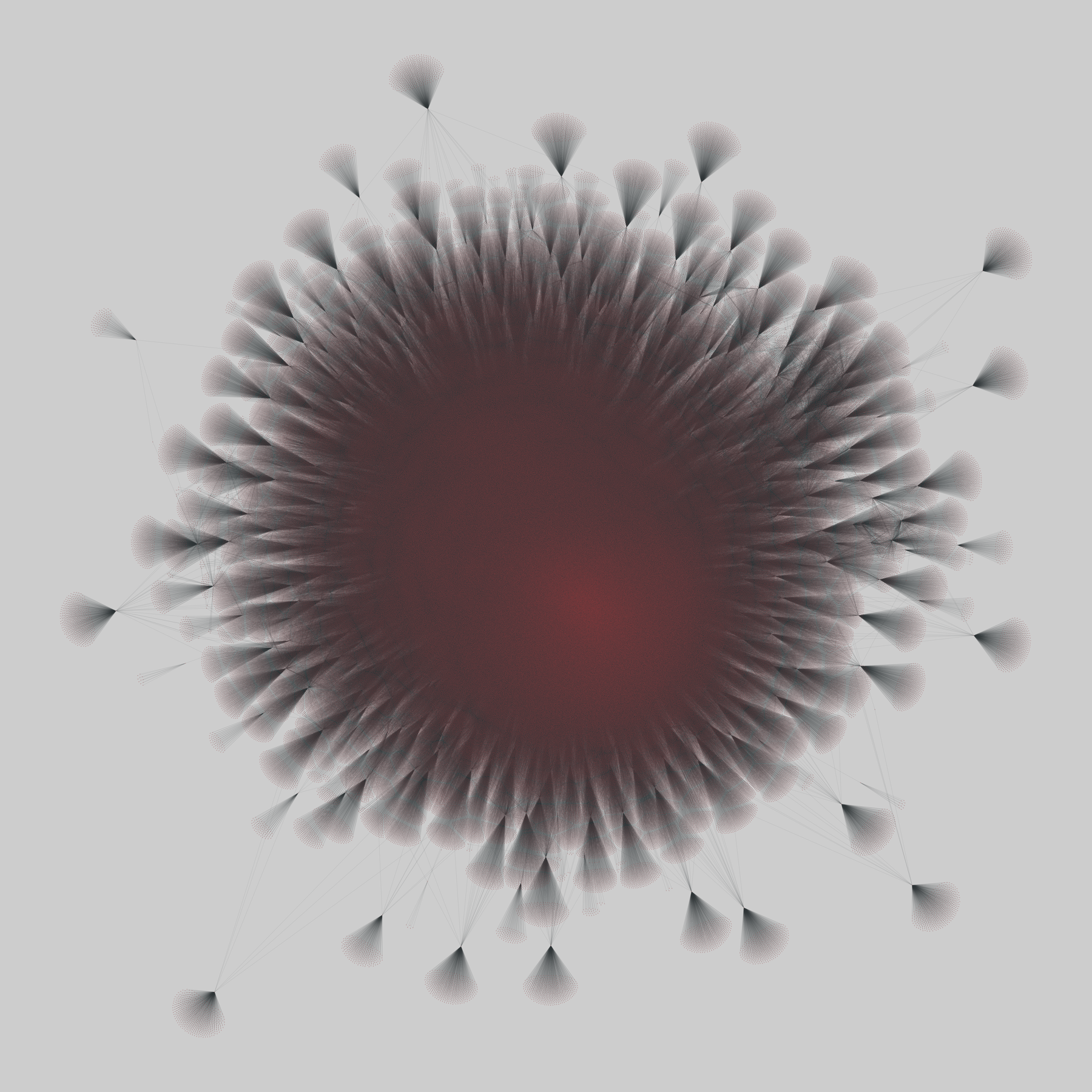
@netzschleuder@social.skewed.de2026-06-30 03:00:17
twitter: Twitter followers (2010)
A directed network of following relationships from Twitter, from a snowball sample crawl across "quality" users in 2009. A directed edge (i, j) indicates that user i follows user j.
This network has 465017 nodes and 834797 edges.
Tags: Social, Online, Unweighted
https://network…
 @hex@kolektiva.social
2026-06-27 04:14:08
- Definite and distinct ecclesiastical government
This is explicitly defined in your legal documents. It's the way in which you "govern" things that are legally owned by the "church." If you're going to start a church with some people, you need to have a way of working together. The more formal you are about writing all this stuff out, the easier it will be when you *inevitably* have conflict. (Conflict is normal, so everyone should expect it.)
I also wrote something up about this. Again, it's an example (using the term "coven", because I like it more) so take it for what it's worth:
Group agreements are collectively defined rules that describe how members should interact. They may function to simplify interactions, ensure access needs are met, or to protect against the emergence of hierarchical behavior.
You can use the following prompts, or define your own:
- How should we interact with each other?
- What are your access needs?
- What would help you feel safe and respected?
- How should we deal with conflict?
- How do we deal with unanswerable questions?
- What is the process by which we update these agreements?
Write down these agreements. Edit them until you reach consensus. If it isn't possible to reach a consensus, the group may need to break apart to form separate covens.
Keep these available to refer to as they may be needed during services. These agreements will change over time. Keep them updated and be sure to check in regularly, perhaps even through a specific yearly ritual, to make sure they all still apply and no more are needed.
@netzschleuder@social.skewed.de2026-05-26 16:00:05
sp_high_school_new: High school dynamic contacts (2011-2012)
These datasets contain the temporal network of contacts between students in a high school in Marseilles, France. The first dataset gives the contacts of the students of three classes during 4 days in Dec. 2011, and the second corresponds to the contacts of the students of 5 classes during 7 days (from a Monday to the Tuesday of the following week) in Nov. 2012.
This network has 126 nodes and 28561 edges.
Tags: Soc…