 @cdarwin@c.im
2025-12-20 00:58:32
U.S. Senator Mike Lee (R-UT) introduced dumb-ass legislation today
that would allow private entities to play at Pirates🏴☠️in the Caribbean
The "Cartel Marque and Reprisal Reauthorization Act"
authorizes felon-president Trump to commission American pirates,
under "letters of marque"
to seize property and persons on land or sea.
Representative Tim Bimbo Burchett (R-TN) introduced the House version of the legislation.

 @leftsidestory@mstdn.social
2025-09-21 00:30:08
On The Road - To Xi’An/ Beings 👁️🗨️
在路上 - 去西安/ 灵 👁️🗨️
📷 Pentax MX
🎞️Kodak Double-X 5222
#filmphotography #Photography #blackandwhite


 @netzschleuder@social.skewed.de
2025-12-20 12:00:07
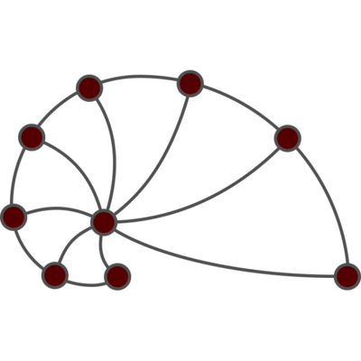
qa_user: User interactions on Q&A websites (2016)
Networks of interactions among users from four online Q&A sites: Stack Overflow, Math Overflow, Super User, and Ask Ubuntu. A directed edge (i,j) indicates a user i responded to user j's post. Edges are timestamped. For each Q&A site, four differently defined networks are provided, based on the definition of an edge: (i) a user answered a question, (ii) a user commented on a question, (iii) a user commented on an answer…

 @adlerweb@social.adlerweb.info
2025-11-20 12:19:09
 @Techmeme@techhub.social
2025-10-20 18:05:40
An interview with Deel CEO Alex Bouaziz, who expects a 2025 profit of $170M to $200M, about the company's $300M round that pushed its valuation above Rippling's (Matt Durot/Forbes)
http://www.

 @marcel@waldvogel.family
2025-12-20 06:05:23
Maintaining accurate timing in virtual machines has always been a challenge. Especially on hosts with many VMs.
Here's a clever solution, hopefully coming soon to a hypervisor or OS near you.
https://uapi-group.org/specifications/specs/vmclock/
@cdarwin@c.im2025-12-19 22:11:09
This white paper provides a comprehensive analysis of modern warfare through five interconnected characteristics that have been prominently displayed throughout the Ukraine conflict:
- The rise of autonomous systems and their impact on force architecture
- The information domain as a critical battleground
- Electronic warfare and spectrum superiority
- The challenges of sustaining logistics in contested environments
- The evolution of air defense strategy
…

 @cdp1337@social.bitsnbytes.dev
2025-10-20 01:45:00
For all 3 ARK SA players still out there, I did a bit of updates to my Linux installer.
Notably work on the management interface which it deploys.
 @hex@kolektiva.social
2025-11-19 06:07:23
Part of why #Trump has always been so hard to pin down politically is that he was always representing highly conflicting interests. Now, as that eats him alive, the GOP is fracturing in to two main groups: the Pinochet/Franco wing and the Hitler wing.
The Pinochet/Franco wing (let's call them PF) are lead by Vance. PF are also a coalition with some competing interests, but basically it's evangelical leaders, Opus Dei (fascist catholics), tech fascists (Yarvinites), pharma, and the other normal big republican donors. They support Israel, some because apartheid is extremely profitable and some because they support the genocide of Palestinian in order to bring the end of the world. They are split between extremely antisemitic evangelicals and Zionists, wanting similar things for completely different reasons. PF wants strong immigration enforcement because it lets them exploit immigrants, they don't want actual ethnic cleansing (just the constant threat). They want H1B visas because they want to a precarious tech work force. They want to end tariffs because they support free trade and don't actually care about things being made here.
The Hitler wing are lead by Nick Fuentes. I think they're a more unified group, but they're going to try to pull together a coalition that I don't think can really work. They're against Israel because they believe in some bat shit antisemitic conspiracy theory (which they are trying to inject along side legitimate criticism of Israel). They are focused on release of the #EpsteinFiles because they believe that it shows that Epstein worked for Mossad. They don't think that the ICE raids are going far enough, they oppose H1Bs because they are racists. They want a full ethnic cleansing of the US where everyone who isn't "white" is either enslaved for menial labor, deported, or dead. But they're also critical of big business (partially because of conspiracy theories but also) because they think their best option is to push for a white socialism (red/brown alliance).
Both of them want to sink Trump because they see him as standing in the way of their objectives. Both see #Epstein as an opportunity. Both of them have absolutely terrifying visions of authoritarian dictatorships, but they're different dictatorships.with opposing interests. Even within these there may be opportunities to fracture these more.
While these fractures decrease the likelihood of either group getting enough people together, their vision is more clear and thus more likely to succeed if they can make that happen. Now is absolutely *not* the time to just enjoy the collapse, we need to keep up or accelerate anti-fascist efforts to avoid repeating some of the mistakes of history.
Edit:
I should not that this isn't *totally* original analysis. I'll link a video later when I have time to find it.
Here it is:
#USPol
@cdarwin@c.im2025-12-19 03:59:28
While fascist ideas never found a foothold among the majority of Americans,
they exerted considerable influence during the period between the first and second world wars.
Extremist groups like
the Silver Shirts,
the Christian Front,
the Black Legion and
the Ku Klux Klan claimed hundreds of thousands of members.
Together they glorified a white Christian nation purified of Jews, Black Americans, immigrants and communists.
During the 1930s and …
